Aerial view of the campus grounds
Add to clipboard
Photograph of campus grounds taken from the north showing the freeway in the foreground, and the newly constructed Arts and Science Building, Calvin B. Hanson Chapel, and Vernon B. Strombeck Library in the background.
George Allen Aerial Photos Ltd.
Aerial view of campus grounds
Add to clipboard
Photograph of campus grounds taken from the southeast showing Douglas Hall in the foreground and the Barnasium behind; aerial photograph.
George Allen Aerial Photos Ltd.
Aerial view of campus grounds
Add to clipboard
Photograph of campus grounds taken from the southwest; aerial photograph.
George Allen Aerial Photos Ltd.
Aerial photograph of TWC site and surrounding area
Add to clipboard
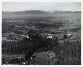
Photograph of the TWC site and surrounding area taken from the east; aerial photograph in which the buildings in the foreground do not belong to the school, but will give way for the construction of the freeway.
George Allen Aerial Photos Ltd.
Aerial view of campus grounds
Add to clipboard
Photograph of campus grounds taken from the southwest; aerial photograph.
George Allen Aerial Photos Ltd.
Aerial view of Seal Kap Farms
Add to clipboard
Photograph of Seal Kap Farm, future site of TWC, taken from the southwest showing all the original buildings, including the barn; aerial photograph.
George Allen Aerial Photos Ltd.
Aerial view of campus grounds
Add to clipboard
Photograph of campus grounds taken from the southwest; the Pond is in the foreground; aerial photograph.
George Allen Aerial Photos Ltd.
Aerial photograph of campus grounds
Add to clipboard
Photograph of campus grounds taken from the southwest, showing the Vernon Strombeck Library and the Arts and Science Building in the foreground.
George Allen Aerial Photos Ltd.
Aerial view of campus grounds
Add to clipboard
Photograph of campus grounds taken from the southwest, showing the Arts and Sceince Building in the foreground and the Barnasium; aerial photograph.
George Allen Aerial Photos Ltd.